The San Francisco Crosstown Trail is one of the city’s greatest ideas, up there with the Mission Burrito and stealing a baseball team from New York. I’ve walked the entire 17-mile length of it twice, and piece-parted my way through some of its better sections multiple times as well. A great deal of thinking and planning went into its creation, ensuring that as much green space as possible would be traversed, and that breathtaking vistas and outlooks would be maximized. Mission accomplished. It’s amazing.
And yet – now that you’ve done the Crosstown Trail – and if you haven’t, I hope you do – wouldn’t it be nice to know that an enterprising citizen has mapped out a different Crosstown Trail? An alternative Crosstown Trail, if you will?
Well what’s so different about it, I hear you sniggering. Let me tell you. First, let me say that, now that I’ve just walked the entire length of mine today (the one I planned online yesterday in about 90 minutes, using Google Maps), I will still cede superiority to the folks who spent months planning the original one. Theirs is demonstrably better – but, and I don’t say this lightly – it’s not light years better. Mine is a pretty damn good representation of San Francisco, and it is one hell of a workout.

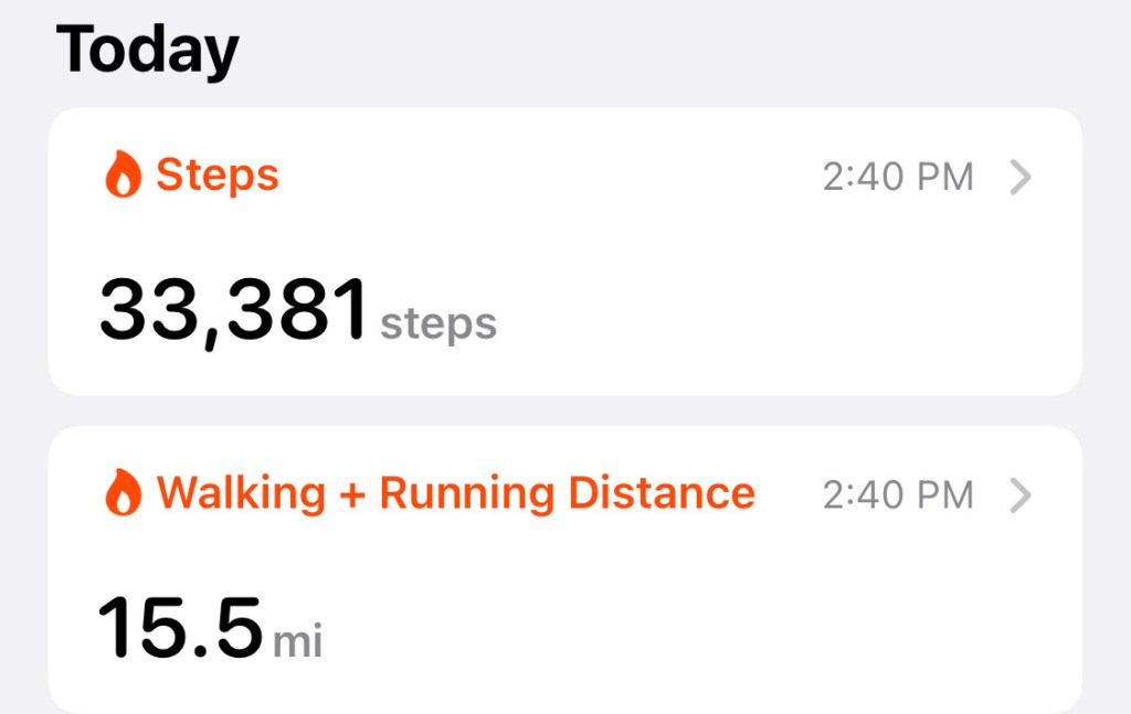
First, mine goes from the northeast corner of the city, at Pier 39, to the southwest corner of the city – the beach at Fort Funston. Just below that beach, it’s Daly City, folks. If you can cross somewhat diagonally from from Pier 39 to Fort Funston, you’ve really covered some distance (15.5 miles!), and seen an incredible cross-section of San Francisco. The original Crosstown Trail goes southeast to northwest (or vice-versa if you do it the other way).
Because mine starts and remains in the most urban parts of San Francisco for much of its length, I’ve tried – as did the original – to maximize both green space and views as best I can. The only time it ever actually crosses the original southeast-to-northwest trail is for about a block or two way up in Golden Gate Heights (I think they share a small stretch on 14th Avenue). Whenever possible, I’ve tried to route the walker into a park, up a staircase, down a staircase, onto a trail and atop a vista. Having lived in San Francisco for 32 years now, I had the benefits of a little “local knowledge” that I laid on ya, but this trip showed me plenty of things I’d never seen before (like, who knew that the Mount Sutro hike behind UCSF was so peaceful and far up in the clouds that it felt like I was getting rained on up there? Who knew about Ina Coobraith Park? Not I).
This trip takes you into North Beach, Russian Hill, Pacific Heights, “NOPA”, the Haight (sort of), Cole Valley, the Inner Sunset, Golden Gate Heights, Parkside, the Sunset and Lake Merced – pretty much in that order.
You’ll see from my photos that it was an exceptionally foggy day today in San Francisco, from the top of the city to the bottom. Locals know: it’s always like this. Or at least it was in the summer of 2021.
Anyway, this is the Alternate Crosstown Trail across the city of San Francisco. I hope you try it – and that you can improve upon it (please leave a comment with any modifications you’ve made after walking it).
- Start on The Embarcadero at Pier 39, right under the flags
- Right on Kearney
- Right on Bay
- Left on Midway
- Left on Francisco
- Right on Grant

- Go 1 block on Grant, and you’ll make a left on Pfeiffer Street to go up the stairs to Jack Early Park
- Then go back down to Grant Avenue and make a left
- Left on Lombard – curves into Telegraph Hill Blvd.
- Up stairs to Pioneer Park / Coit Tower
- back out the other side; make a right on Filbert Street
- Take the first stairs you see down to Filbert Street
- Once you hit Washington Square Park, cut through it diagonally
- Right on Union
- Left on August Alley
- Right on Green
- Left on Mason
- Right on Vallejo
- Go up into Ina Coolbrith Park (amazing place)
- At the top, make a left on Taylor (it looks like the park may continue on the other side of Taylor, but I was pretty tired from all the stairs at that point)
- Right on Broadway (more stairs, but now you are walking on top of the Broadway Tunnel for quite a few blocks)

- Left on Polk (stroll through Russian Hill; grab a drink from a bistro or something)
- Right on Clay
- After several blocks, Clay dead-ends right at the staircase into Lafayette Park
- Come out opposite side, and make a right on Laguna (use the bathroom and refill your water bottle first)
- Left on Washington. Now you’re going to see some pretty stunning homes.
- After several blocks, Washington dead-ends into the Alta Plaza Park stairs. Go up those stairs
- At the other side, go left on Scott
- Right on Clay
- After many blocks, left on Lyon
- Once you hit Geary, you’ll need to make a right and go across a crosswalk; come back down Geary and make a right back onto Lyon
- Left on Terra Vista
- Right on Baker

- Right on Turk (check out the Church of John Coltrane at 2097 Turk. I’ve lived here forever and had never known it was there)
- Left on Lyon (so many great Victorians around here)
- Cross through the Panhandle park, and get right back on Lyon
- Lyon dead-ends at Buena Vista Park. Take the stairs up!
- If you keep going up and to the right, you’ll end up at Upper Terrace Street. Make a right when you get there
- Go on Upper Terrace for a while until you see a small stairway on your right. These are the Mt. Olympus Stairs. Take ’em!
- Once you’re up there, you’ll see a large roundabout with an obelisk in the middle. Keep to the right, and you’ll continue on Upper Terrace
- Take the “Monument Way Stairs” on your right
- Right on 17th
- Keep going on 17th until it dead-ends at Stanyan, then make a slight left on Stanyan
- Immediately you’ll see a trailhead to your right. It’s not labeled as the “Historic Trail Trailhead”, but it is, and that’s what you want
- Follow it for a looooong time through the woods until it comes to the West Ridge Trail sign, and then make a right onto the West Ridge Trail
- Here’s a tip: the last 20 or so feet of the West Ridge Trail is really steep. It doesn’t even feel like a trail at all – just a hill you need to find your way down from. Be careful, OK?

- Left on Crestmont
- Then – after less than a minute – a staircase appears to your right. Take it! This staircase goes on forever, but it’s all down, and for that you’ll be thankful
- When it finally ends, right on Warren
- Continue through 7th Avenue – Warren has now become Lawton
- Left on 12th
- When 12th hits Noriega, you’ll see a big wall in front of you; on the other side of that is a staircase called Selma that you’ll be taking. You just need to go right or left to get around the wall (I went right and made a U-turn)
- Right on Ortega
- Same thing here – you’ll want to take stairs up called “Cascade Walk” that you’ll see quickly, but you need to get around a wall first
- Take Cascade Walk Stairs (tired yet?)
- Takes you onto Funston Avenue; go straight
- Right on Aerial Way (another stairway – down this time)
- Left on 14th Avenue
- Right on Mandalay (more steps going down)
- Turns into Pacheco
- Walk on Pacheco for a while, then make a left on 22nd Avenue
- Right on Taraval
- Left on 28th into Parkside Square Park (good bathroom/water station to your left)

- 28th basically hits a small wooded trail; go down it until you hit Wawona
- Right on Wawona
- Walk on Wawona for a while until you get to 39th Avenue
- Left on 39th; cross Sloat Avenue
- Slight right onto Skyline Blvd, which hugs Lake Merced
- Walk on Skyline (left-hand side) for nearly a mile until you either start hearing guns going off (there’s a shooting range) or see Fort Funston to your right
- Carefully cross the street at the light and enter Fort Funston (read the sign first – some great history here)
- Stay on the trail to the right – the Coastal Trail – takes you directly to Funston Beach.
- YOU’RE DONE!